Drone survey · Photogrammetry · BIM · Earthworks
Drone Technology in Construction: Reducing Cost, Improving Accuracy
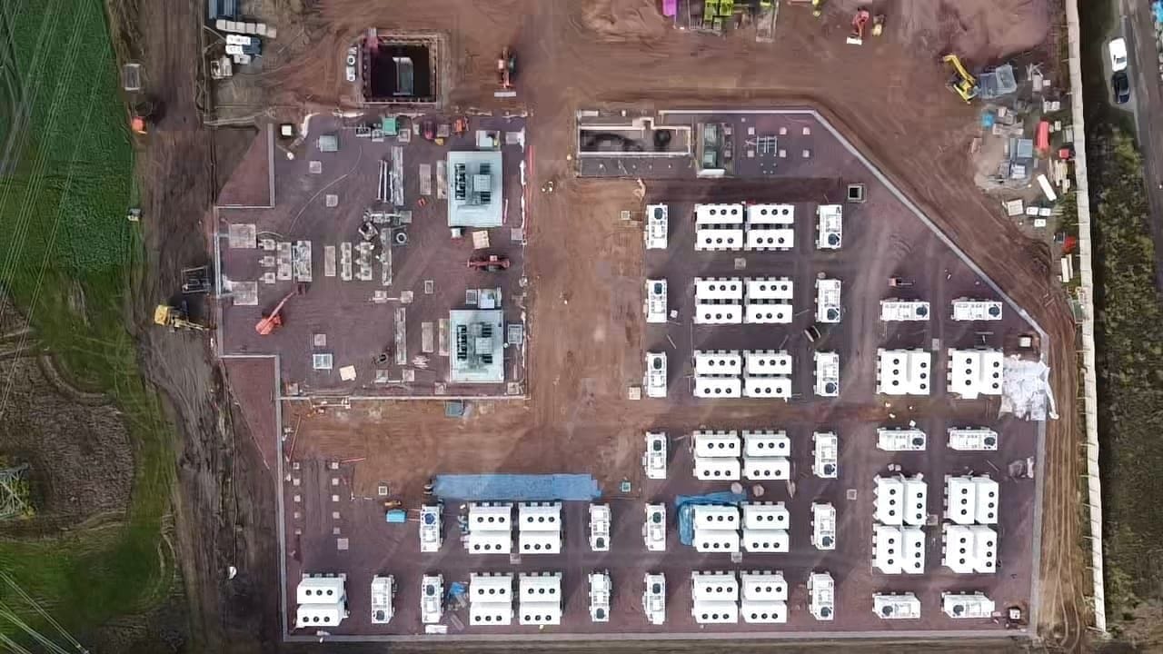
Drones for construction have moved from novelty to instrument. On a civil and enabling-works programme, a survey-grade unmanned aircraft is no longer there to take aerial photographs — it is a measurement device that captures a site faster, more completely and more safely than a crew on the ground. Used well, drone technology in construction reduces cost and improves accuracy at the same time, because the same flight that documents progress also produces the data engineers need to verify quantities and check work against the model.
Maveric treats drone survey and photogrammetry as part of its self-delivered method, not a bolt-on service. Our own crews fly, process and reconcile the data against the design, and the output flows into the same in-house digital backbone that runs the rest of the works. This article sets out where the value actually comes from: earthwork volumes, progress monitoring, as-built capture feeding BIM, and inspection without putting people at height.
What a survey drone actually measures
A construction drone survey is photogrammetry at scale. The aircraft flies a planned grid at a fixed height and captures hundreds of overlapping images of the site. Software then matches common points across those images to reconstruct the surface as a dense three-dimensional point cloud, from which an orthomosaic, a digital terrain model and contours are derived. The result is a measurable record of the ground, not just a picture of it.
Accuracy depends on control. Ground control points are surveyed in with GNSS and used to tie the photogrammetric model to a real coordinate system, so distances, levels and volumes can be trusted against the design datum. With proper control and image overlap, a well-flown survey can resolve the surface to within a few centimetres over an open site — close enough to drive earthworks decisions and to check as-built geometry.
- Orthomosaic — a corrected, scaled aerial image you can measure on
- Digital terrain and surface models for levels, slopes and drainage falls
- Dense point cloud for volumes, sections and clash checking
- Contours and break-lines exported straight into the design package
Cut and fill volumes you can defend
Earthwork quantities are where a drone survey pays for itself first. A traditional volumetric survey by total station samples the ground at points and interpolates between them; a drone captures the whole surface. Compared against a design surface or a previous flight, the difference between the two models gives cut and fill volumes across the entire site, with stockpiles measured individually rather than estimated.
That changes how earthworks are managed. Volumes can be reconciled weekly rather than at milestones, haulage and muck-away planned against measured quantities, and disputes over how much material moved settled with a dated model rather than an opinion. Catching a discrepancy between as-dug and design early — before the next layer goes down — is far cheaper than discovering it at handover.
Drone construction site monitoring and progress control
Regular flights turn a site into a time series. A weekly or fortnightly capture, taken from the same flight plan each time, produces a consistent visual and measured record of how the works are progressing. Set against the programme, drone construction site monitoring shows what has actually been built against what was planned, and makes slippage visible while there is still time to act on it.
The same record is a communication tool. A single orthomosaic with the model overlaid tells a client, a main contractor and a design team more in one view than a written report, and it does so from a shared, verifiable source. Because every flight is dated and geolocated, it also forms a defensible audit trail — useful for valuations, for variations and for any later question about sequence and timing.
As-built capture feeding BIM
Drone data is most valuable when it does not stop at the survey department. The point cloud and surface models import directly into the BIM environment, where as-built geometry can be compared to the federated model. Formation levels, duct-bank corridors, drainage runs and earthwork profiles can all be verified against design before they are covered up, and the verified condition recorded for the handover model.
This is how a site builds a digital record rather than a folder of photographs. Each capture is a checkpoint: surface accepted, levels confirmed, quantity reconciled. By handover, the BIM model is not an idealised version of the design but a documented account of what was constructed, supported by dated survey evidence — exactly the kind of record mission-critical clients expect to receive.
Safer inspections, fewer people at height
Survey is only half the case. The clearest safety benefit of drones in construction is keeping people out of harm's way. Stockpile faces, deep excavations, partially built structures, sheet-piled basements and high-voltage compounds can all be inspected from the air without sending an operative onto an unstable edge, up a ladder or into a live exclusion zone. The inspection still happens; the exposure does not.
That sits squarely within how Maveric works — self-delivered, with safety designed into the method rather than added afterwards, and consistent with our safety management system, which is aligned to ISO 45001. Flights are planned around exclusion zones and live services, segregated from working plant, and flown by competent operators under the relevant aviation rules. The aircraft is treated like any other piece of plant: with a method, a brief and a clear reason for being in the air.
Best practice for drone construction site monitoring
The difference between useful drone data and expensive noise is discipline. Good results come from a repeatable workflow rather than ad-hoc flights, and from treating each capture as a survey with a defined purpose. The practices below are the ones that make the data trustworthy enough to build decisions on.
- Establish and resurvey fixed ground control so every flight ties to the same datum
- Fly a consistent plan — same height, overlap and grid — so captures stay comparable over time
- Set the flight interval to the programme: more often during earthworks, less once enclosed
- Reconcile each capture against the design model, not only against the previous flight
- Plan flights around exclusion zones, live services and working plant, under the applicable aviation rules
- Archive every dataset with its date and control, so the record stands up later
Frequently asked questions
How do drones reduce cost on a construction site?
They capture a whole site quickly and measure it accurately, so earthwork volumes, stockpiles and progress can be reconciled often rather than estimated. Catching discrepancies against the design early — before work is covered up — avoids rework, and a dated model removes the disputes that drive cost on quantities and sequence.
How accurate is a drone survey for construction?
With surveyed ground control points and good image overlap, a well-flown photogrammetric survey can resolve an open site to within a few centimetres. Accuracy depends on the control, the flight plan and the processing, not just the aircraft, which is why the workflow matters as much as the hardware.
What is photogrammetry in construction?
Photogrammetry reconstructs a three-dimensional surface from many overlapping aerial photographs by matching common points between images. On a construction site it produces an orthomosaic, terrain models and a point cloud that can be measured for volumes, levels and as-built geometry.
Can drone data be used in BIM?
Yes. The point cloud and surface models from a flight import directly into a BIM environment, where as-built geometry can be compared to the federated design model and the verified condition recorded for the handover record.
Are drones safe to use on an active construction site?
Used properly, they improve safety by removing the need to put people on unstable edges, at height or inside live exclusion zones to inspect or survey. Flights should be planned around hazards and working plant, segregated from operations and flown by competent operators under the relevant aviation rules.
How often should a site be flown for progress monitoring?
Set the interval to the programme: more frequent flights during active earthworks when the surface changes quickly, and less often once a structure is enclosed. Flying a consistent plan each time keeps captures comparable and turns the site into a reliable time series.